Version
December 6, 2025
Highlights (2025-12-05)
Civica Changelog
Welcome to the Civica Changelog. This document showcases all the amazing features we've built to help Jamaica see needs, move help, and stay coordinated.
Coming Soon
- Organization directory with verified badges. Surface trusted response teams, contact info, and service areas so residents know who is on the ground nearby.
- Crew console. Give invited volunteers a dedicated hub to view assignments, update statuses, and coordinate logistics.
- Better satellite image coverage. Fresh post-Melissa satellite imagery from Maxar (Vantor) open data program fills the gaps where NOAA imagery is still missing so responders can inspect inland damage without blind spots.
- Community Stage. A live audio community stage where public panels can be hosted, situational updates can be shared, and private DMs are included for coordination.
- Field Mode. A simplified interface dedicated to crews in motion so they can log updates, drop pins, and sync data with minimal taps while on the ground.
- Combo pins. Capture several needs or services in a single composite pin so dense areas don’t get cluttered and crews can read everything in one card.
- Mesh networking. Peer-to-peer offline syncing so crews can swap data face-to-face while offline and everything pushes automatically once any relief team member reconnects to the internet.
[Unreleased]
Nothing queued yet. Track incoming fixes and features here as they land.
[0.3.1] - 2025-12-06
🎉 Latest Release — Civica 0.3.1 introduces a live Watchtower for admins to keep the platform trustworthy, plus a round of polish that keeps daily use breezy.
Highlights (2025-12-05)
- Live Watchtower. Owners now have a private console with real-time health stats so issues surface quickly without exposing internal tooling to the public.
- Smoother accounts. The Fix Request Center tucks itself away when empty, mobile tabs take up less space, and signup now reminds existing members to sign in instead of double-registering.
- Reliable layers & uploads. Overlay drawers behave on phones, the utilities legend no longer floats after a reset, map warnings stay put, and pin media up to 10 MB uploads without hiccups.
[0.3.0] - 2025-11-24
🎉 Release Recap — Civica 0.3.0 captures everything shipped on November 24, 2025.
Added - Fix Operations & Overlay Controls (2025-11-24)
-
Fix Request Center + guided edit submissions. “Suggest an edit” now walks residents through photos, coordinates, status, or removal steps. After sending, you can jump straight to the new Fix Request Center on the Accounts page to follow every request, and pin owners get an inbox listing the changes their locations need.
Fix Request Center walkthrough cycling through each edit type (coordinate fixes, image swaps, removal, more). -
One-tap data refresh. When a fresh map build ships, a glowing “Update available” banner appears so you can clear old downloads and reload the newest tiles without hunting through settings.
Update banner nudging a refresh and clearing cached tiles in one tap. -
Trauma content warning. Before loading the most graphic satellite imagery, Civica now shows a gentle warning so you can opt out if you need a mental health break.
Trauma banner gently fades in, lets you dismiss, and stays out of the way. -
Overlay memory. The map remembers which overlays and filters you toggled on (and syncs that choice across tabs) with a reset button if you ever want to start clean.
Overlay reset button restoring your layer stack back to the default preset. -
NOAA mosaic picker. Post-event imagery lists every NOAA flight and lets you toggle the new Hurricane Melissa mosaic on or off while Civica silently proxies the tiles for faster loads.
NOAA mosaic picker preview showing satellite overlays being toggled. -
Stagnant Water & Underserved markers. New presets make it easy to flag mosquito-prone pools or entire neighborhoods that still haven’t received help, and the needs dashboard weighs those alerts automatically.
Quick-add presets drop stagnant water and underserved community alerts in seconds.
Added - Need Intelligence & Tile Controls (2025-11-24)
-
Advanced filtering & layers. Tap-to-toggle overlays (crews, resources, hazards) with richer controls for serious operators.
-
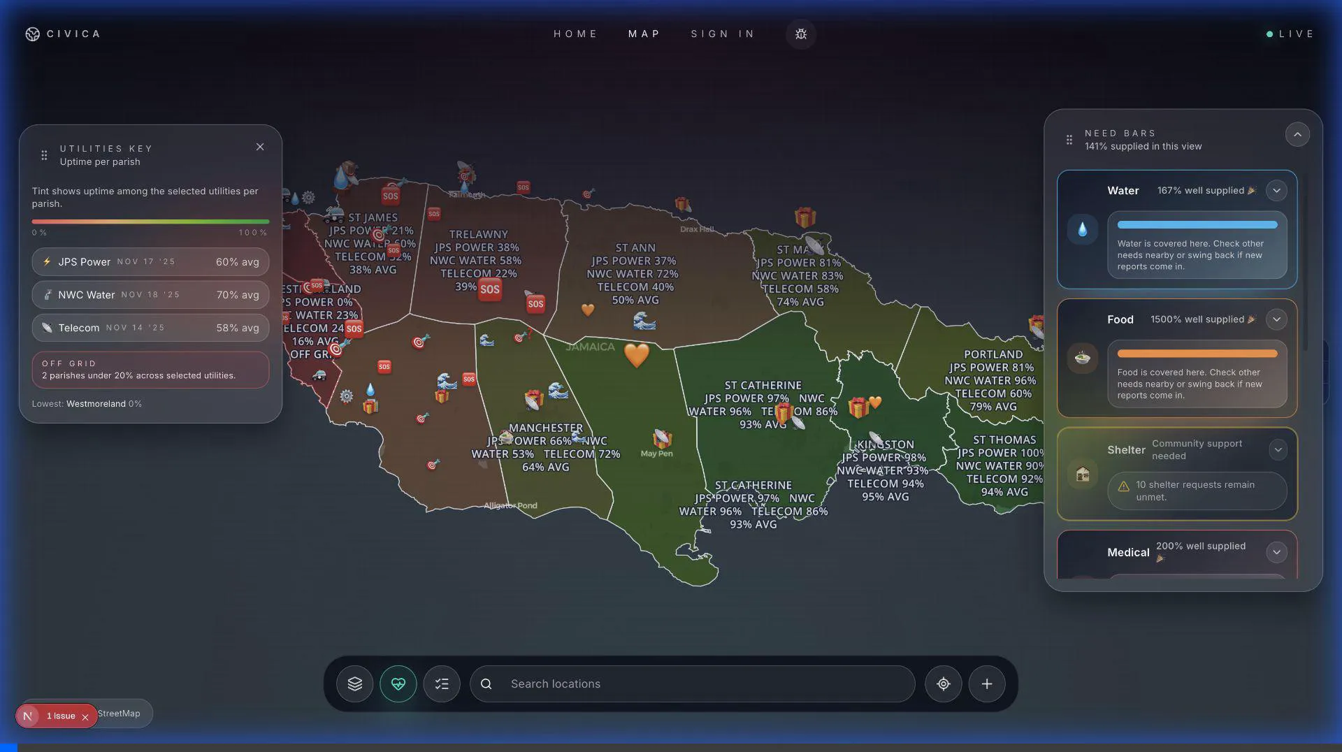
Need score analytics. Area-level choropleths that visualize unmet needs and supply saturation to steer deployments.
-
Area-level choropleths. Area-level choropleths now tint every parish and community boundary in proportion to saturation so ops leads can scan underserved corridors at a glance.
Need Bars auto-sort keeps the most urgent categories surfaced as requests flow in. -
Heat maps for pin clusters. Heat maps for pin clusters turn dense corridors into gradient halos so dispatch can see activity spikes without tapping into dozens of overlapping pins.
-
Offline tile management. Smarter caching + manual controls so teams can pre-load imagery before heading into the field.
Changed - Map Polish (2025-11-24)
- Relief Beacon pins now display a box emoji (📦) to better match supply pickup points.
Fixed - Imagery Reliability (2025-11-24)
- NOAA post-event tiles no longer vanish at high zoom levels. Civica retries each flight, caps zoom where NOAA data ends, and gracefully falls back to the standard imagery when needed, so you always see something useful.
Added - Map Features & Search
Interactive Map
- ✨ Pan and zoom controls — Smooth map navigation across Jamaica
- 🔍 Live search — Find locations, parishes, and pins in real-time
- 📍 Location services — Center map on your current position
- 🗺️ Parish boundaries — Visual overlays showing electoral divisions
Search Functionality
- Search by parish name (Kingston, St. Andrew, etc.)
- Search by pin title or description
- Search by keywords (food, water, shelter, GoFundMe)
- Live results as you type
- Quick navigation to search results
Added - Pin Interactions
View Pin Details
- Click any pin to see full information
- View images and custom details
- Access external links (GoFundMe campaigns, etc.)
- See location and contact information
- Scroll through detailed descriptions
Pin Categories
- ⚠️ Hazards — Flooding, Landslides, Debris, Downed Lines, Washouts, Structural Damage
- 🆘 Needs — Rescue, Food, Water, Medical, Shelter, Elderly/Child Support, Building Supplies
- 🛠️ Resources — Community Kitchens, Clinics, Charging Stations, Shelters, Repair Workshops
- 📦 Donations — Collection Drives, Staging Sites, Hygiene Kits, Tool Drives
Added - Community Contributions
How to Add a Pin
- "Add to Map" Button — Tap the ➕ button in the bottom right (adds pin to center of screen)
- Long Press — Press and hold anywhere on the map to drop a pin exactly there
- Right Click — Secondary click (two fingers on trackpad) on desktop to drop a pin
Contribution Types
- 🚨 Report Hazard — Mark dangers like flooding or road blockages
- 🆘 Request Help — Post needs for supplies, rescue, or support
- 🏪 Pin Help Hub — Mark locations offering resources or services
- 📦 Pin Donation Drive — Add donation collection points
Quick Add Options
- 🌊 Flooding (with depth indicators)
- 🆘 Rescue Needed
- 🍲 Community Kitchen
- 📦 General Donation Drive
Added - Offline Support
Progressive Web App (PWA)
- 📱 Easy Install — Simply visit civicajm.org and add to home screen
- 💾 Offline map caching for parishes
- 🔄 Background sync when reconnected
- 📊 Storage management and diagnostics
Post-Event Tile Caching
- Cache disaster imagery tiles for offline access
- Configurable cache size limits (default ~120 MB)
- Automatic eviction of oldest tiles
- 7-day default TTL for cached tiles
Added - Privacy & Security
Privacy-First Design
- 🔒 No personal information required to view map
- 🎯 Location jittering (50-200m) on public pins
- 👤 Optional contact information when adding pins
- 🛡️ Secure visitor identity system
Security Enhancements
- Hardened visitor identity flows
- Rate limiting on link previews
- Production environment validation
- Regression tests for auth flows
Added - User Experience
Authentication & Onboarding
- 📧 Email-based signup and login
- ✅ Legal consent and terms acceptance
- 🎫 Invite code support for crew onboarding
- 📱 Mobile-optimized auth layouts
- 🔐 Secure OTP confirmation flow
Map Interactions
- Improved pin click interactions
- Polished hero and footer layouts
- Responsive design for all devices
- Graceful offline mode detection
- Private browsing mode support
Added - Data & Integration
GoFundMe Integration
- 💰 Display GoFundMe campaign pins
- 🖼️ Campaign images and descriptions
- 🔗 Direct links to fundraising pages (with built-in fraud protection)
- 📊 Campaign details in custom fields
Post-Melissa Satellite Imagery (November 19, 2025)
- 🛰️ Post-event satellite imagery overlay
- 📸 Visual damage assessment capabilities
- 🗺️ Before/after comparison support
- 🔍 High-resolution imagery for affected areas
- 🔜 Coming Soon: Multi-layer overlay for full map view
Utility Status Overlays (November 19, 2025)
- ⚡ Power service status by parish
- 💧 Water supply status tracking
- 📡 Telecommunications coverage maps
- 📊 Parish-level restoration metrics
Data Management
- Incremental public pin sync
- Lazy account pin pagination
- Pin address geocoding cache
- Sitrep ingestion tooling
- Real-time monitoring dashboard
Improved
Search & Discovery (November 19, 2025)
- 🔍 Enhanced search reliability — Fixed back-to-back search issues
- ⚡ Faster search results — Improved query performance
- 🎯 Better result accuracy — Refined search algorithm
Performance
- ⚡ Faster initial page load
- 🗺️ Optimized map tile loading
- 📱 Better mobile performance
- 💾 Efficient caching — Reduced initial data payload from ~24 MB to ~1 MB while displaying more pins
- 🔄 Improved sync reliability
- 🗄️ Database optimization (November 18, 2025) — Significantly reduced disk I/O usage
User Interface
- 🎨 Polished glassmorphism design
- 📐 Improved spacing and layouts
- 🎯 Better touch targets for mobile
- ✨ Smoother animations and transitions
- 🌓 Enhanced dark mode support
Admin & Moderation (November 18, 2025)
- 🛠️ Improved locations admin — Enhanced management tools
- ✅ Report verification — Better workflow for verifying community reports
- 📊 Need classification — Fixed classification issues for need bars
Fixed
Authentication
- Fixed missing email in OTP confirmation flow
- Improved auth redirect fallback to civicajm.org
- Better handling of private browsing mode
- Graceful visitor identity persistence when database unavailable
Map Features
- Fixed post-event tile toggle within zoom gates
- Improved map interaction reliability
- Better handling of missing data
- Fixed pin clustering edge cases
Data Sync
- Improved offline sync reliability
- Better error handling for failed syncs
- Fixed duplicate pin issues
- Enhanced data validation
Infrastructure (November 18, 2025)
- 🔧 Resolved CDN caching issues affecting asset delivery
- 📦 Fixed static asset loading from content delivery network
- 🗺️ Improved reliability of map tile and image serving
- 🔍 Comprehensive database audit — Optimized queries and indexes
- ⚠️ Service outage recovery — Successfully resolved CDN and backend service disruptions
Technical
Infrastructure
- Canonical site URL: civicajm.org
- Analytics integration for usage insights
- Link preview generation with rate limits
- Offline map tile proxy with caching
- Backend service redundancy and fallback support
Developer Experience
- Updated custom TypeScript types
- Improved documentation
- Playwright test artifacts ignored
- Simplified quick option styling
- Better error logging and debugging
[0.2.0] - 2025-11-15
Added
- Initial map implementation with vector tiles
- Basic pin creation and viewing
- Parish boundary overlays
- User authentication system
- Database backend integration
Technical
- Next.js App Router setup
- TypeScript configuration
- Tailwind CSS styling
- IndexedDB for local storage
[0.1.0] - 2025-11-10
Added
- Project initialization
- MVP specification and roadmap
- Brand identity (Civica - A Community Effort)
- Core architecture decisions
- Development environment setup
Version History
- 0.3.1 (2025-12-06) — Watchtower intelligence, Account polish, Reliability fixes
- 0.3.0 (2025-11-20) — Map features, search, contributions, offline support
- 0.2.0 (2025-11-15) — Initial map and authentication
- 0.1.0 (2025-11-10) — Project foundation
How to Use This Changelog
This changelog is designed for users and stakeholders to understand what's new in Civica. Each release includes:
- Added — New features and capabilities (latest examples)
- Improved — Enhancements to existing features (see upgrades)
- Fixed — Bug fixes and corrections (reference fixes)
- Technical — Behind-the-scenes improvements (platform notes)
Video demonstrations are included to show features in action.
Feedback & Support
Found a bug or have a feature request?
- Email: vanessa@civicajm.org
- Report issues: Use the feedback button in the app
Civica is a community effort to help Jamaica see needs, move help, and stay coordinated.
- fix: preserve & display chosen cover media (background uploads, pin preview) and add cover helpers test.
- Organization directory with verified badges. Surface trusted response teams, contact info, and service areas so residents know who is on the ground nearby.
- Crew console. Give invited volunteers a dedicated hub to view assignments, update statuses, and coordinate logistics.
- Better satellite image coverage. Fresh post-Melissa satellite imagery from Maxar (Vantor) open data program fills the gaps where NOAA imagery is still missing so responders can inspect inland damage without blind spots.
- Community Stage. A live audio community stage where public panels can be hosted, situational updates can be shared, and private DMs are included for coordination.
- Field Mode. A simplified interface dedicated to crews in motion so they can log updates, drop pins, and sync data with minimal taps while on the ground.
- Combo pins. Capture several needs or services in a single composite pin so dense areas don’t get cluttered and crews can read everything in one card.
- Mesh networking. Peer-to-peer offline syncing so crews can swap data face-to-face while offline and everything pushes automatically once any relief team member reconnects to the internet.
Realtime Relief Map
Pan, zoom, search, and overlay civic data so responders can triage Jamaica at a glance.
Offline Field Kit
Install Civica as a PWA, cache disaster tiles, and keep diagnostics handy when bandwidth drops.
Community Contributions
Hazards, needs, and verified help hubs stay transparent so every crew knows what changed last.